Seven years ago an exceptionally strong El Niño took hold in the Pacific Ocean, triggering a cascade of damaging changes to the world’s weather. Indonesia was plunged into a deep drought that fueled exceptional wildfires, while heavy rains inundated villages and farmers’ fields in parts of the Horn of Africa. The event also helped make 2016 the planet’s hottest year on record.
Now El Niño is back. The odds are decent that this one will be another strong event, raising concerns of extreme weather in the coming months. And a strong El Niño is very likely to set another global heat record.
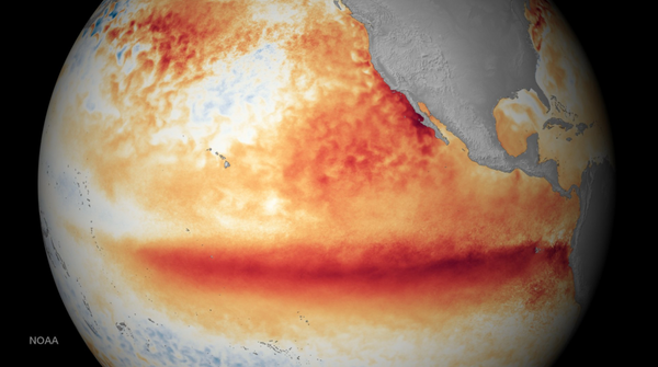
El Niño is part of a natural climate cycle called the El Niño/Southern Oscillation. Its hallmark is a tongue of warmer-than-normal waters that stretches across the eastern and central portions of the tropical Pacific Ocean. Its opposite state is called La Niña, which features colder-than-average waters in the same parts of the Pacific. The ocean seesaws between these states every two to seven years, though the past three years unusually saw three back-to-back La Niñas. The change in ocean surface temperatures during these events alters where heat is released into the atmosphere overhead. That in turn influences atmospheric circulation patterns and sets off a domino effect that can cause major changes to the weather all over the world.
On supporting science journalism
If you're enjoying this article, consider supporting our award-winning journalism by subscribing. By purchasing a subscription you are helping to ensure the future of impactful stories about the discoveries and ideas shaping our world today.
When and whether various regions see these changes depends on location. The closer a place is to the tropical Pacific, the more immediate and likely the effects will be. Impacts also tend to be more pronounced when an El Niño reaches its peak strength, which happens in the Northern Hemisphere’s winter. “The stronger it is, the more confident we are in certain impacts occurring,” says Michelle L’Heureux, a forecaster at the National Oceanic and Atmospheric Administration’s Climate Prediction Center. NOAA forecasts a 56 percent chance the current El Niño will be strong. (One of the benchmarks for measuring an El Niño is that temperatures in a particular part of the tropical Pacific are at least 0.5 degree Celsius, or 0.9 degree Fahrenheit, above normal. A strong El Niño occurs when those temperatures are 1.5 degrees C, or 2.7 degrees F, above normal.)
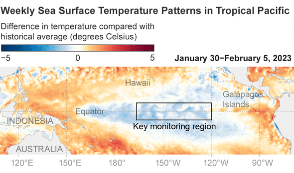
Credit: National Oceanic and Atmospheric Administration, styled by Scientific American
But even if this El Niño does develop into a strong event—or an extremely strong one—that’s “not ever a guarantee” that any particular weather change will occur, L’Heureux says. Strong El Niños often bring rainy weather to southern California, but that rain did not materialize during the 2016 episode, for example. That is because El Niño isn’t the only game in town; other natural climate cycles and local influences also play a role.
The way El Niño changes the world’s weather is linked to what are called the Walker and Hadley circulations—essentially big vertical loops of air, with the former oriented along the equator and the latter oriented perpendicular to it. Tropical Pacific Ocean waters are typically warmer in the west than in the east. Those warm waters fuel convection, with hot, moisture-laden air rising and fueling rain until it hits the tropopause, where the lowest layer of the atmosphere, the troposphere, meets the stratosphere. The air then flows from west to east, descends over the eastern Pacific and subsequently flows from east to west along Earth’s surface. But during an El Niño, everything shifts eastward: air rises over the eastern Pacific and subsides over Southeast Asia. This shift leads to drier weather in the latter region that can cause major droughts and food shortages and can fuel wildfires.
The shifting Walker circulation also brings descending air to northern South America and the Caribbean during an El Niño. That subsidence tends to keep a lid on hurricane activity in the Atlantic Ocean because it inhibits the convection that drives such storms. The changing circulation patterns also lead to more crosscutting wind shear, which can stymie storm development. But this year that influence will be competing against stunning, record-breaking hot temperatures in the Atlantic that will provide ample fuel for storms. With these competing influences, NOAA currently predicts a near-average season, with 12 to 17 named storms, five to nine of which could become hurricanes.
U.S. weather during an El Niño is also affected by the Hadley circulation, which runs in a north-south loop on either side of the equator. During an El Niño, shifts in that circulation push the subtropical jet stream—a current of fast-moving air that guides storm systems across the country—farther to the south in the winter months. That typically leads to cooler, wetter conditions across the southern U.S. and warmer-than-usual conditions across the northern tier of the country and parts of Canada.
Other weather changes that occur during an El Niño include warmer, drier conditions in eastern Australia, parts of India and southern Africa. Parts of Kenya, Somalia and Ethiopia tend to see increased rainfall, which could be a boon after years of climate-change-fueled drought. But if too much rain falls too quickly, it can bring flooding and mudslides and can help spread waterborne diseases.
One of the biggest certainties with an El Niño is that global temperature will ratchet up, as they always do during El Niño years, because the ocean releases exceptional amounts of heat into the atmosphere. That heat will be added on to the global warming driven by humans burning fossil fuels and could spur this year or next to be the hottest year on record, as happened in 2016. (The effects on global temperature lag the El Niño by a few months.) The 2016 El Niño was comparable in strength to the one in 1998, but the former was 0.5 degree C (0.9 degree F) hotter than the latter because of global warming. Adding to the likelihood of a record year with the current El Niño is the fact that the global average ocean temperature was already setting records before the event was declared, L’Heureux says. “That’s pretty bonkers,” she adds.